உள்ளடக்கத்திற்குச் செல்
Tap to Lanka

ஆதாம் பாலம் (இராமர் பாலம்)

மன்னார், மன்னார் மாவட்டம்

வழிகாட்டலைப் பெறுக

A remarkable chain of limestone shoals and sandbanks between Sri Lanka and India, famous for its natural beauty, marine wildlife and Ramayana heritage.

பார்வையிட சிறந்த நேரம்
Early morning during calm weather, preferably at low tide.
திறந்திருக்கும் நேரம்
No fixed public visiting hours confirmed. Boat excursions depend on local authorisation and sea conditions.
நுழைவுக் கட்டணம்
Shore viewing is generally free. Boat tour and protected-area fees must be confirmed locally.
உடை விதிமுறை
Comfortable lightweight clothing, sandals or suitable footwear, sunglasses and a sun hat.
தேவையான நேரம்
30–60 minutes for shore viewing; 2–3 hours for an organised boat excursion.

சிறப்பம்சங்கள்

  • Unique chain of limestone shoals and sandbanks
  • Legendary Rama Setu from the Ramayana
  • Scenic turquoise sea and sandy islands
  • Protected marine national park
  • Rich marine and coastal biodiversity
  • Migratory seabirds and marine wildlife
  • Historic Sri Lanka–India maritime connection
  • Beautiful coastal photography opportunities

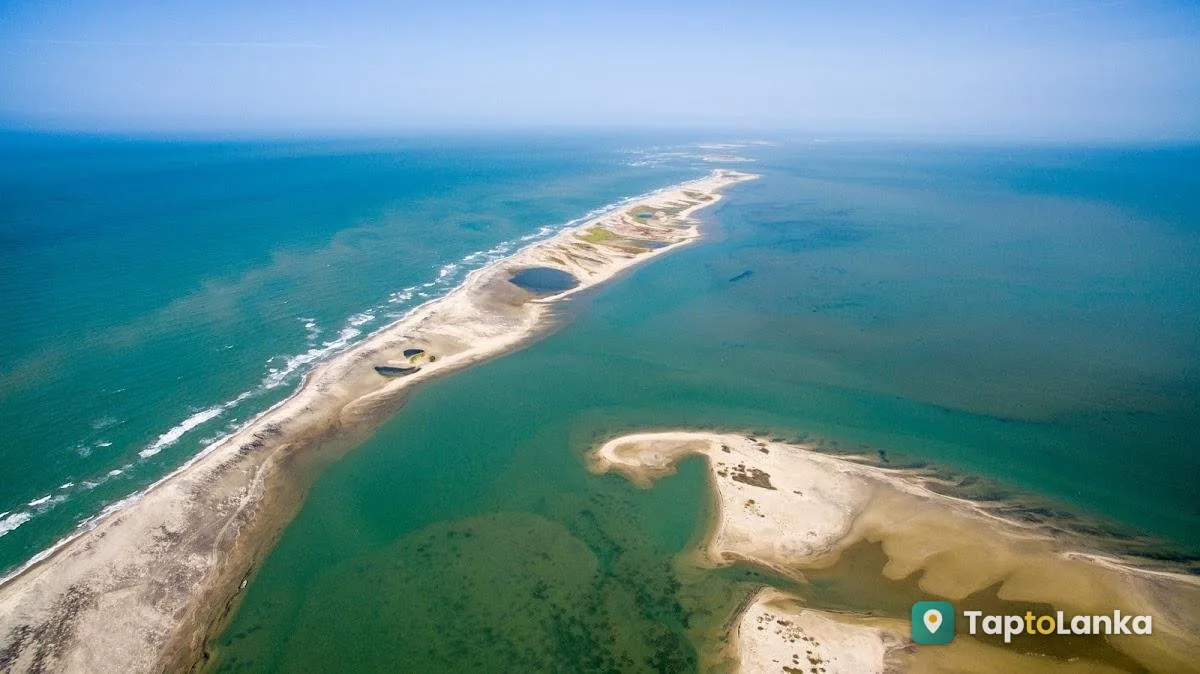
Adam's Bridge, also known as Rama Setu or Rama's Bridge, is one of the most fascinating natural and culturally significant landmarks in South Asia. Located between Mannar Island in northwestern Sri Lanka and Rameswaram Island in southern India, this remarkable formation consists of a series of limestone shoals, shallow sandbanks and small sandy islands stretching across the sea. Its unusual geographical appearance, historical associations and religious significance make it an important attraction in the Mannar region.

The formation stretches approximately 48 kilometres between the two countries, separating the Gulf of Mannar from the Palk Strait. The shallow waters surrounding the sandbanks create a beautiful coastal landscape with turquoise seas, pale sandy formations and small islands. Some parts of the formation remain submerged, while others become more visible depending on tides and seasonal sea conditions.

Adam's Bridge holds special religious importance in Hindu tradition because of its association with the ancient Indian epic, the Ramayana. According to the epic, Lord Rama and his army of Vanaras constructed a bridge across the sea to reach Lanka and rescue Sita from Ravana. This traditional account is the reason the formation is commonly called Rama Setu or Rama's Bridge. The story continues to hold deep spiritual and cultural meaning for many Hindu devotees.

From a geological perspective, Adam's Bridge is generally understood as a natural chain of sandbanks and limestone shoals shaped by coastal processes, sediment movement and changing sea levels. Its formation and past relationship with the surrounding coastline remain subjects of geological study. The religious traditions surrounding Rama Setu and the scientific explanations of its physical formation are distinct aspects of the site's significance.
புகைப்படங்கள்

எப்படிச் செல்வது

Travel from Mannar town towards Talaimannar via the main island road. Continue to Talaimannar's western coast. Permitted boat trips may be arranged locally.

பார்வையாளர்களுக்கான குறிப்புகள்

Check boat permits and weather conditions. Carry water, sunscreen and binoculars. Do not attempt to walk to India or enter restricted sandbanks. Protect marine wildlife.

அடிக்கடி கேட்கப்படும் கேள்விகள்

Where is Adam's Bridge located?

Adam's Bridge extends from Mannar Island in Sri Lanka towards Rameswaram Island in Tamil Nadu, India.

Why is Adam's Bridge called Rama Setu?

According to the Ramayana, Lord Rama's army built a bridge across the sea to reach Lanka and rescue Sita.

Can tourists walk across Adam's Bridge to India?

No. The sandbanks are separated by sea channels and are subject to safety, conservation and international border restrictions.

Can tourists visit Adam's Bridge by boat?

Boat excursions may be available from Talaimannar when authorised and weather conditions are suitable. Confirm arrangements locally.

What is the best time to visit Adam's Bridge?

December to March is generally recommended for marine sightseeing, subject to daily weather and sea conditions.

பார்வையாளர் மதிப்புரைகள்

இதுவரை மதிப்புரைகள் இல்லை. இங்கே சென்றிருக்கிறீர்களா? மற்ற பார்வையாளர்களுக்கு உங்கள் குறிப்புகளைப் பகிருங்கள்.

மதிப்பாய்வு எழுத உள்நுழையவும்
திருத்தம் பரிந்துரைக்கவும் அல்லது தவறான தகவலைப் புகாரளிக்கவும்

அருகிலுள்ள மேலும் இடங்கள்

அனைத்தையும் பார் →
மன்னார் ஒல்லாந்தர் கோட்டை
வரலாற்று & பாரம்பரிய இடங்கள்

மன்னார் ஒல்லாந்தர் கோட்டை

மன்னார், மன்னார் மாவட்டம்

A historic coastal fortress built by the Portuguese in 1560 and later restored by the Dutch, famous for its colonial architecture and scenic lagoon views.

மடு மாதா தேவாலயம்
தேவாலயங்கள் தவறவிடக்கூடாதது

மடு மாதா தேவாலயம்

மன்னார், மன்னார் மாவட்டம்

One of Sri Lanka's most sacred Catholic pilgrimage sites, famous for its historic Virgin Mary statue, peaceful atmosphere and annual Madhu Festival.

கீரி கடற்கரை
கடற்கரைகள்

கீரி கடற்கரை

மன்னார், மன்னார் மாவட்டம்

A peaceful sandy beach on Mannar Island, popular for relaxing seaside walks, swimming in suitable conditions and beautiful sunset views.

வழிகாட்டலைப் பெறுக பயணம் திட்டமிடு